Road trip Around Arizona
Phoenix To Superior, Miami, Globe, Winkelman,
Roosevelt Lake, Apache Lake,
Canyon Lake & back to Phoenix.
In November 1870 the first significant settlement by white men was made in what was later to be called Superior. In that month General George Stoneman, commanding officer of troops in Arizona against the Indians, built a small camp at the base of what the Mexicans called "Tordillo" Mountain. The soldiers began calling the butte "Picket Post," because they used it as a sentinel point to guard their settlement. At the foot of Picket Post they began constructing a pack-mule trail towards the Pinal Mountains.

Superior, AZ

Road Kill

Superior, Arizona


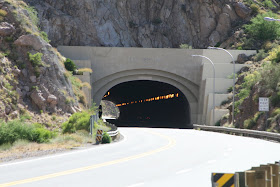
The Queen Creek Tunnel
Is a roughly ¼ mile long (400 m) tunnel on US 60, just east of Superior, Arizona. Completed in 1952, the Queen Creek Tunnel replaced the Claypool Tunnel, linking Phoenix with Safford by way of Superior and Globe/Miami


Miami Az Miming Tailings

No it's not snow

Miami (Western Apache: Goshtłʼish Tú) is a town in Gila County, Arizona, United States. Miami is a classic Western copper boomtown, though the copper mines are largely dormant now.

Is a town in Gila and Pinal counties in the U.S. state of Arizona. According to 2006 Census Bureau estimates, the population of the town was 444, almost all of whom lived in Gila County

El Capitan Pass Historical Marker, S.R. 77, Arizona

Raven


Theodore Roosevelt Lake

Parkinsonia florida (Blue Palo Verde; syn. Cercidium floridum)
A species of palo verde native to the southwestern United States (southeastern California, southern Arizona) and northwestern Mexico (Sinaloa, Sonora, Baja California). Its name means "green stick" in Spanish, referring to the green trunk in which the tree does photosynthesis.

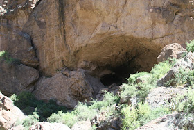
Tonto National Monument consists of the ruins of two cliff dwellings established by the Salado Indians in about 1300 AD. The southeast-facing settlements were built quite high up a steep hillside within well-protected natural caves overlooking the Tonto Basin, which is now flooded forming Theodore Roosevelt Lake. Daily, 8:00 a.m. - 5:00 p.m. except Christmas Day.
Lower Cliff Dwelling trail closes to uphill travel at 4:00 p.m.
Individual Fees - $3.00 per adult - good for 7 days; children under 16 are free.
Directions
Tonto National Monument
26260 N Az Hwy 188 # 2
Roosevelt, AZ 85545


Theodore Roosevelt Lake
Theodore Roosevelt is the largest lake or reservoir located entirely within the state of Arizona
Roosevelt Lake is the oldest of the six reservoirs constructed and operated by the Salt River Project. It also has the largest storage capacity of the SRP lakes with the ability to store 1,653,043 acre feet (2.03900 km³) of water at full capacity.
Length: 22.4 miles
Shoreline: 128 miles
Capacity: 1,653,043 acre-feet
Surface acreage when full: 21,493 acres
Maximum depth: 188 feet

 Expansion
In 1996 a $430 million modification project was completed that raised the height of the dam to 357 feet and expanded the lake's storage capacity by 20 percent -- enough for 1 million more people. This 77-foot increase offers six Valley cities 304,729 new acre-feet of water storage to the dam
Renovations at Roosevelt Dam used 444,000 cubic yards of concrete, enough to pave a two-lane road from Phoenix to Tucson.
The quantity of reinforcing steel used in the dam's renovation -- 6.7 million pounds -- would be 849 miles long if placed end to end. This is the distance from Phoenix to Denver

Where the old road use to be before they raised the dam.

100 years of hydro power from Roosevelt Dam
First electricity delivered to Valley on permanent basis started Oct. 1, 1909


Apache Lake
Formed by Horse Mesa Dam, Apache Lake is long and narrow and is the second largest Salt River Project lake. The Apache Lake Marina and Resort is one mile from the main highway and features a motel, gas station, coffee shop, picnic supplies and a trailer park for 12 units. A boat ramp and dock are at the resort, and a county sheriff's aid station is nearby.
Game fish in Apache Lake include walleye, largemouth and smallmouth bass, red ear sunfish, bluegill, channel catfish and crappie.


There's a road up there some where. The Apache Trail, or
AZ 88 at this point it's a one lane road up the mountain

Fish Creek
The jagged Superstition Mountains and adjacent ranges, due east of Phoenix in central Arizona, have many steep, narrowish canyons amongst great expanses of sharp, eroded, igneous rock with several peaks over 4,000 feet and a dense covering of saguaro cacti. One particularly fine canyon is formed by Fish Creek, a lengthy drainage that flows from the center of the mountains in a north-westerly direction towards the Salt River, joining it just below Apache Lake.

Fish Creek Bridge


Mike Hites

Lizards


The Apache Trail

What Way

Now that's a mail box
Not posted but I found that where you find this kind of
mail boxs the roads head to the Apache and Canyon lakes dams.

Tortilla Flat Az.
It is located in the central part of the state, northeast of Apache Junction. It is the last surviving stagecoach stop along the Apache Trail.
Originally a camping ground for the prospectors who searched for gold in the Superstition Mountains in the mid to late 1800s, Tortilla Flat was later a freight camp for the construction of Theodore Roosevelt Dam. From this time (1904) on, Tortilla Flat has had a small (<100 people) but continuous population. A flood in 1942 badly damaged the town, resulting in many residents moving away. Today Tortilla Flat is made up primarily of a small store and restaurant, which were constructed in the late 1980s after a fire consumed the existing store and restaurant on the same site. Several hiking trails into the Superstition Mountains begin near Tortilla Flat.

Canyon Lakes many one lane bridges


Canyon Lake
Of the four lakes created through the damming of the Salt River, Canyon is the smallest, but arguably the most picturesque. The magnificent rock formations and high red-rock canyon walls create a picture of unique southwestern natural beauty. Hidden coves peek out around every turn on the lake allowing for quite fishing, picnicking and boating.
Canyon Lake, just 16 miles northeast of Apache Junction on Route 88 is considered the gateway to the Apache Trail.
Angler’s flock to Canyon Lake to slip into a secluded cove and fish for walleye, largemouth bass, yellow bass, rainbow trout, bluegill, channel catfish and crappie.Numerous plant, bird, and wildlife species including Big Horn sheep, javelina, and deer are in abundance along the rocky edges of the lake.
The saguaro cactus (Carnegiea Gigantea )
Te state symbol of Arizona, appearing on all car license plates, and provides a universally recognized image of the Southwest. It is the largest and one of the slowest growing of all cacti, reaching up to 15 meters high and living for several centuries. Plants can weigh up to 8 tons, partly because of the large amount of water the stems can hold - after rainfall the cactus can absorb hundreds of gallons in a short time. The saguaro may be only 6 inches high after 10 years, and the characteristic branched appearance is reached only after around 80 years.

The saguaro cactus (Carnegiea Gigantea ) blooming
The night blooming flowers appear April through May and the sweet, ruby-colored fruit matures by late June. Saguaro flowers are self incompatible thus require cross pollination. Large quantities of pollen are required for complete pollination as there are numerous ovules. A well-pollinated fruit will contain several thousand tiny seeds.
The ruby red fruit ripen in June. Each fruit contains around 2000 seeds plus sweet fleshy connective tissue. The fruit are highly edible and prized by local people. The O'odham tribes have a long and rich history of saguaro fruit use.

Prickly pear cacti typically grow with flat, rounded platyclades that are armed with two kinds of spines; large, smooth, fixed spines and small, hairlike spines called glochids, that easily penetrate skin and detach from the plant. Many types of prickly pears grow into dense, tangled structures.
The fruit of prickly pears, commonly called cactus figs, Indian[3] fig or tuna,[4] is edible,
Medical uses
The fruit of prickly pears, commonly called cactus figs, Indian[3] fig or tuna,[4] is edible,
Medical uses
The End!


