McDowell Sonoran Preserve

The Gateway Access Area was dedicated in May 2009. The Gateway is located east of Thompson Peak Parkway, one-half mile north of Bell Road (view map). This Access Area is the largest and most significant entry point to the Preserve. The facility has 200 parking spaces, restrooms, shade ramadas, a dog comfort station, water fountains, and an equestrian staging area with 16 trailer parking spaces, water troughs, hitching rails, and a shade ramada. The Gateway is also the site of the planned Desert Discovery Center.
The Gateway is designed to have a minimal impact on the fragile desert environment. Green building elements incorporated in the facility include solar power generation, rainwater harvesting, solar water heating, rammed earth walls constructed of native soil from on-site excavation, structural steel made of high recycled content, highly efficient mechanical equipment, native landscaping, and parking lot and path surfaces made of stabilized decomposed granite.
A joint committee of the Tourism Development Commission and the McDowell Sonoran Preserve Commission has been appointed to manage Phase 2 planning to establish a Desert Discovery Center (DDC) at the Gateway to the McDowell Sonoran Preserve. The discovery center is envisioned to provide opportunities for residents and visitors to discover the story of the Upper Sonoran Desert. Through exhibits and environmental experiences presented in a natural setting, the center will inspire learning about the desert through its programs designed to encourage preservation and instill a sense of harmony with and respect for the desert environment in which we live.
Phase 1
Planning was completed by a team comprised of ConsultEcon, Inc. and Exhibit Design Associates, who were hired to develop concepts for the DDC through a public involvement process.
View the Report (PDF/16MB/205pp) The report is a big file and may take time to download.
Phase 2
Planning will focus on concept refinements, conducting a statistically significant target market survey to determine the character and content of the DDC preferred by residents, visitors and business interests and identifying preliminary building configuration and design opportunities. A preliminary business plan will be prepared based on the results of these tasks.


In 1990, Scottsdale citizens (through the non-profit McDowell Sonoran Land Trust - today called the McDowell Sonoran Conservancy) initiated the preservation of Scottsdale's McDowell Mountains and Sonoran Desert. The vision is to preserve approximately 36,400 acres, equivalent to 1/3 of Scottsdale's total land area. This area is referred to as the Recommended Study Boundary for the McDowell Sonoran Preserve (RSB) (pdf/2912kb/1pg).


When land in the RSB is acquired by Scottsdale, it becomes part of the McDowell Sonoran Preserve. The Preserve will consist of mountains, Sonoran Desert, and natural corridors linking to natural open space in adjacent communities and to the Tonto National Forest and the Maricopa County Regional Park. The vision is to create a large sustainable natural desert habitat for wildlife and desert flora, available for appropriate passive recreation public use.
In 1995, Scottsdale voters approved a .2% tax increase to purchase land in the 16,460 acre original RSB (pdf/1363kb/1pg). In 1998, voters approved using the sales tax to purchase land in the 19,940 acre expanded RSB (pdf/2124kb/1pg).
A total of 19,643 acres in the RSB is State Trust Land. In 1998 all of the State Trust Land in the original boundary- 2,762 acres, and 317 acres adjacent to the County Regional Park (submitted by the County at the request of Scottsdale) was, reclassified as suitable for conservation under the Arizona Preserve Initiative (API). In 2001, 13,021 acres of State Trust Land in the expanded boundary were reclassified as suitable for conservation under the API.
In 2004, Scottsdale voters approved an additional .15% increase in the sales tax for land acquisition and for access area amenities. When completed, the McDowell Sonoran Preserve will be one of the largest urban preserves. The Preserve will be larger than Tempe and Paradise Valley combined.
Land desired for the Preserve was identified based upon:
1) Access potential
2) Unique geological, historical and archaeological features
3) Ecosystem & wildlife habitat
4) Scenic quality
5) The potential for appropriate passive public use (i.e. hiking, biking, rock climbing, equestrian)
6) Corridors connecting natural open space areas
The objective is that land in the McDowell Sonoran Preserve be preserved in as pristine of a state as possible as this generation's legacy to those that follow while providing appropriate passive recreational use opportunities so all can enjoy and experience the splendor of the Preserve.
The importance of saving these lands is underscored by Arizona Game and Fish, which considers the McDowell Mountains the most significant wildlife habitat in the valley outside the Tonto National Forest.


"Preserve Connections" Hiking Tours
In partnership with the McDowell Sonoran Conservancy the City of Scottsdale is offering for the fourth year, Preserve Connections , a seasonal hiking program offered to Scottsdale residents who may not have direct access to visit, experience and learn more about the McDowell Sonoran Preserve.
Certified Conservancy Stewards will lead pre-registered participants on hikes that highlight Sonoran Desert flora and fauna.
Participants must sign liability waivers.
Hikers must: Wear sturdy, covered shoes/boots and hats (sunglasses suggested).
Bring at least 2 quarts of water per hiker, sunscreen and energy snacks.
No strollers; children must either walk or be carried.
No pets except for certified assistance animals.
Registration will be limited and offered on a first-come, first-served basis.
For more information, call (480) 312-3111.
Hikes are led by experienced McDowell Sonoran Conservancy Stewards who are expert in desert subjects. Frequent stops will be made to admire and discuss surroundings. Questions are encouraged.
The McDowell Sonoran Conservancy (MSC) is a non-profit organization staffed almost entirely by volunteers. It advocates the land-conservation cause, conducts desert-education programs and helps maintain the city-owned McDowell Sonoran Preserve and state-trust-land areas that have been designated for preservation, but not yet acquired. To reach the McDowell Sonoran Conservancy, call (480) 998-7971.

Jamie


Darren and Jamie


 Arizona Sunset
Sunrise Saddle via 145th Way—The Sunrise Trail from the east rises about 1,000 feet in about 1.5 miles to a saddle with splendid views in all directions. This 3-mile roundtrip is considerably steeper than the trail’s western portion and requires a higher level of fitness. About 3 hours.


Jamie a great hiker that kicked my butt hiking up.

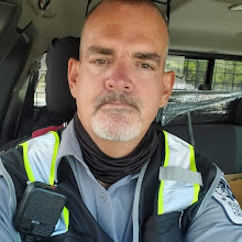
Darren (me) on top of Sunrise Trail off behind me is Fountail Hills Az.

Me and Jamie hiking as we are at the top of the Sunrise Trail.

Fountain Hills is a town in Maricopa County, Arizona, USA, neighboring the Fort McDowell Yavapai Nation, Salt River Pima-Maricopa Indian Community and Scottsdale, AZ. The population is 24,669, as of the 2006 Census. It has the world's fourth tallest fountain. Charles W. Juels' Fountain Hills Observatory is nearby. The town has two annual fairs, a local art fair and the Fountain Hills Great Fair which incorporates arts and a carnival. The town has the only Thanksgiving Day parade west of the Mississippi River.
The eponymous fountain was built in 1970 by Robert P. McCulloch, the year before the reconstruction of the London Bridge in Lake Havasu City, another of McCulloch's projects. The fountain sprays water for about 15 minutes every hour. The plume rises from a concrete water-lily sculpture in the center of a large man-made lake. The fountain, driven by three 600 horsepower (450 kW) turbine pumps, sprays water at a rate of 7000 gallons per minute though an 18-inch nozzle. With all three pumps and under ideal conditions, the fountain reaches 560 feet (170 m) in height[4], though in normal operation only two of the pumps are used, with a fountain height of around 300 feet (91 m) feet. When built, it was the world's tallest fountain and held that record for over a decade.
Fountain Hills is located at 33°36′17″N 111°43′43″W / 33.60472°N 111.72861°W / 33.60472; -111.72861 (33.604811, -111.728526)[3][page needed]. According to the United States Census Bureau, the town has a total area of 18.2 square miles (47.2 km²), of which, 18.2 square miles (47.1 km²) of it is land and 0.1 square miles (0.1 km²) of it (0.27%) is water.

THE END!


2 comments:
WOW! Two more trails at the McDowell Mountain Preserve would be awesome. I've been looking at Scottsdale properties for sale and have found one that I really like. I think living so close to so many outdoor activities will be amazing. Sereno Canyon is in North Scottsdale, and the McDowell Mountains are pretty much the back yard to the community, how perfect is that?
The Scottsdale City Council and special interests are pushing to take 30 acres from the Gateway preserve to build a 74,000 sq ft Desert Discovery Center (DDC) in the Gateway preserve at a cost of $74 million. They are seeking to create a commercial enterprise (along with restaurants, shops, etc) inside the delicate preserve. This is being done WITHOUT a vote from the public.
Watch this video from Councilman Guy Phillips (made this with his own money) https://youtu.be/cJk_tsttCKM
Let's keep the Preserve a preserve and say NO to the DDC being built in the Gateway Preserve. Tell Mayor Lane, the City Council and the DDCS to find another place to build the Desert Discovery Center! citycouncil@scottsdaleaz.gov
Post a Comment