Darren
A pond and Weaver's Needle in the back ground.
This Wilderness was established in 1984, and contains approximately 60,740 acres with a major mountain rising up in its center from the desert foothills. The Four Peaks themselves are visible for many miles, and are one of the most widely recognized landmarks in central Arizona. The rapid change in elevation produces interesting and unique plant and animal communities. Elevations range from 1,900 feet near Apache Lake to 7,600 feet on Brown's Peak.
The Great Western Trail is a unique corridor of braided and paralleling trails for both motorized and non-motorized users. The trail system traverses 4,455 miles through Arizona, Utah, Idaho, Wyoming, and Montana. It incorporates stunning desert and canyon landscapes, plateaus, woodlands, dense forests and alpine meadows. It links 18 National Forests, Tribal, State and BLM administered lands and encompasses the most diverse vegetation, topography and wildlife in the western United States.
Jakes Corner, Arizona
Theodore Roosevelt Lake the western end.
Located roughly 80 miles (130 km) northeast of Phoenix in the Salt River Valley, Theodore Roosevelt is the largest lake or reservoir located entirely within the state of Arizona
Roosevelt Lake is the oldest of the six reservoirs constructed and operated by the Salt River Project. It also has the largest storage capacity of the SRP lakes with the ability to store 1,653,043 acre feet (2.03900 km³) of water at full capacity.
Salt River Project Employee Living Area
Prior to completion of the bridge in October 1990, traffic drove over the top of the dam. The bridge itself earned rare distinction when the bridge was named one of the top 12 bridges in the nation in November 1995. The American Consulting Engineers Council cited the bridge for overall design, size, eye-appeal and design challenge. Other bridges cited were the Golden Gate Bridge and Brooklyn Bridge
The $21.3 million bridge was built to take traffic off the top of Roosevelt Dam. Roosevelt Lake Bridge is the longest two-lane, single-span, steel-arch bridge in North America. The bridge, spans 1,080 feet across Roosevelt Lake providing two-way traffic. The original dam-top roadway was designed to allow two Model-T Fords to pass abreast, but today's recreational vehicles and full-size automobiles are too wide to permit two-way traffic.
Stopping the lake sludge
Former President Theodore Roosevelt dedicated the dam named in his honor March 18, 1911. The reservoir contained 526,875 acre feet of water and was at elevation 163.15 on the dam, the day of the 1st dedication. At 4:15 p.m., the car carrying Roosevelt rounded the point from which he took his first view of the dam. The sight of Roosevelt's car, was the signal for the discharge of 11 guns at the dam, followed by the cheers from the hundreds gathered (upwards of 1,000 people attended the event.) The U.S. flag and the blue Reclamation Service flag floated above the parapets of the dam. Roosevelt said the two proudest achievements of his administration were the Reclamation Act and the Panama Canal.
The old Dam Road
I was temped to go further
Rebar not like now a days rebar
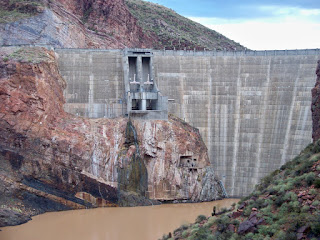
Roosevelt Dam has received a 450,000 cubic yard concrete facelift. After eight years of construction, $430 million, and 849 miles of reinforcing steel (re-bar), the Safety of Dams modifications at Roosevelt Dam are complete. The modifications raised the historic dam 77 feet to 357 feet.
Prior to completion of the bridge in October 1990, traffic drove over the top of the dam. The bridge itself earned rare distinction when the bridge was named one of the top 12 bridges in the nation in November 1995. The American Consulting Engineers Council cited the bridge for overall design, size, eye-appeal and design challenge. Other bridges cited were the Golden Gate Bridge and Brooklyn Bridge.
A challenging aspect of the Theodore Roosevelt Dam modification project was designing a concrete overlay for the dam that would be compatible with the underlying masonry structure. The Bureau of Reclamation chose a single-curvature approach using conventional mass concrete placed in 10-feet high, 70-feet wide blocks, ranging in thickness from 10 to 50 feet. The first concrete block was placed in September 1992 and the final block was placed June 28, 1995 raising the dam to 357 feet tall. The additional 77 feet of dam height increased the water conservation storage capacity by 20 percent and provides for more than 1.8 million acre-feet of flood storage. The new mass concrete blocks with vertical joints were placed as alternating odd-even cantilevers. Reclamation's quality control testing program requires close inspection of the concrete batching and placing operations, and regular testing of cast concrete and concrete components. Mass concrete compressive strengths average 800 pounds per square inch in seven days based on 12 by 24 inch cylinders, and 4,500 pounds per square inch in one year based on 12 inch cores.
This looks like some thing out of D-Day may be a old bunker. But its a tunnel leading to the top of the Roosevelt Lake Dam.
Deep it's not a cave or a mine. It's more like old drill bit holes to blast out the side of the mountain.
The old missile silos never know.
Old Time Photo's the way the Dam use to look.
In 1990
The End!
.jpg)
.JPG)
.jpg)
.jpg)
.jpg)
.jpg)
.jpg)
.jpg)
.jpg)
.jpg)
.jpg)
.jpg)
.jpg)
.jpg)
.jpg)
.jpg)
.jpg)
.jpg)
.jpg)
.jpg)
.jpg)
.jpg)
.jpg)
.jpg)
.jpg)
.jpg)
.jpg)
.jpg)
.jpg)
.jpg)
.jpg)
.jpg)
.jpg)
.jpg)
.jpg)
.jpg)
.jpg)
.jpg)
.jpg)
.jpg)
.jpg)
.jpg)
.jpg)
.jpg)
.jpg)
.jpg)
.jpg)
.jpg)
.jpg)
.jpg)
.jpg)
.jpg)
.jpg)
.jpg)
.jpg)
.jpg)
.jpg)
.jpg)
.jpg)
.jpg)
.jpg)
.jpg)
.jpg)
.jpg)
.jpg)
.jpg)
.jpg)
.jpg)
.jpg)
.jpg)
.jpg)
.jpg)
.jpg)
.jpg)
.jpg)
.jpg)
.jpg)
.jpg)
.jpg)
.jpg)
.jpg)
.jpg)
.jpg)
.jpg)
.jpg)
.jpg)
.jpg)
.jpg)
.jpg)
.jpg)
.jpg)
.jpg)
.jpg)
.jpg)
.jpg)
.jpg)
.jpg)
.jpg)
.jpg)
.jpg)
.jpg)
.jpg)
.jpg)
.jpg)
.jpg)
.jpg)
.jpg)


2 comments:
nice shots of the bridge. Any bike trails out there?
The az trail
Post a Comment