.jpg) There is a rough line around most of the Taylor fire near Sycamore Canyon, and some fire crews plan to begin heading home tomorrow, said Jeannie Gilbertson, a spokeswoman with the team managing the fire.
There is a rough line around most of the Taylor fire near Sycamore Canyon, and some fire crews plan to begin heading home tomorrow, said Jeannie Gilbertson, a spokeswoman with the team managing the fire.The fire, reported Sunday morning, has burned 3,545 acres, and crews are working on reinforcing fire lines today, said Gilbertson, who is with the Northern Arizona Incident Management Team.
There are 595 firefighters working the fire.Many firefighters will leave by Saturday, she said.“They’re just looking to make sure the lines are getting strong, there’s no spotting,” she said.
Also, the protective fire-resistant wrap surrounding Fernow Cabin, which is rented to the public, is being removed.Some roads are planned for re-opening to the public on Friday, but some closures will also remain in place.
FIRE FOLDED INWARD
The 160 firefighters working for John Thornburg, a division supervisor, set burns totaling a little less than a linear mile Monday, folding the fire in on itself to contain it and build a line.
It's been an aggressive fire at times, with embers flung ahead of the main fire starting new fires and throwing more embers.
Tuesday was calmer, he said.And the crews had established about 3 miles of burned area forming a fire line between the blaze and the headwaters of West Fork.
The fire has largely grown to the northeast since Monday, toward the areas blocked by fire lines. Sycamore Canyon is the largely uncontained side of the blaze, ringed with sheer cliffs."It's pretty rough country, and if we were to get more fire down into Sycamore Canyon, it'd be more difficult to fight," Thornburg said.
A tent city was forming along Woody Mountain Road, where hot shots and equipment operators slept between shifts and helicopters landed and departed.
As of Monday, this fire cost an estimated $500,000 to fight.
By the time it's contained, projected at Aug. 30, the cost is expected to be something like
$3 million.
The biggest fire of this season on the Coconino National Forest was 4,000 acres
 Joseph Luttman of the Coconino National Forest stands in the Lookout Tower at Turkey Butte and points across a smoky horizon caused by the Taylor Fire. The Taylor Fire, southwest of Flagstaff, has grown to around 3,545 acres.
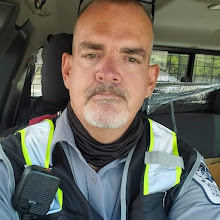
.jpg) Division Supervisor John Thornburg talks about the Taylor fire on Tuesday near the fire line.
Division Supervisor John Thornburg talks about the Taylor fire on Tuesday near the fire line..jpg) A helicopter flies over the smoke of the Taylor fire near Sycamore Canyon.
A helicopter flies over the smoke of the Taylor fire near Sycamore Canyon..jpg) Dome tents line the field where firefighters are making camp while fighting the Taylor fire, southwest of Flagstaff.
Dome tents line the field where firefighters are making camp while fighting the Taylor fire, southwest of Flagstaff..jpg) Scorched trees smolder in the wake of the Taylor Fire, a 3,500 acre wildfire that is burning southwest of Flagstaff
Scorched trees smolder in the wake of the Taylor Fire, a 3,500 acre wildfire that is burning southwest of FlagstaffIncident Fact Sheet Date: 8-19-09
Taylor Fire Information Center 928-226-4600 (Hours: 8 a.m. to 3 p.m.) fireinfo@nazteam.com
Fire Name: Taylor Fire
Time/Date Started: Sighted at 6 a.m. on August 16, 2009
Location: Twenty-two miles southwest of Flagstaff, Arizona in Sycamore Wilderness on the
Coconino National Forest
Cause: Unknown/under investigation.
Fuels: Ponderosa pine, bug kill trees, pinon-juniper, brush
Size: 3545 acres
Percent Contained: 65 percent
Resources Committed: 11 hotshot crews, nine regular crews, three Type 1 helicopters, one Type 3 helicopter, two lead planes, one air attack plane, four air tankers, eight engines, two dozers, and six water tenders. 595 fire personnel.
Predicted Weather: Winds: 10-20 mph out of the west. Relative humidity: 9 percent.
Temperature: 79-90 degrees.
Yesterday’s fire behavior: No significant fire behavior was observed. Residual fuels were consumed and primarily smoked and smoldered.
Concerns: Heavy smoke and falling ash have lessened significantly, but are still of concern, particularly in the Verde Valley area. Area closures will impact hunting season in the fire area.
Restrictions: Forest Roads 231, 538, and 535 are closed. All trailheads leading into the southeastern portion of Sycamore Canyon are also closed.
Today’s strategy: Crews will focus on securing containment lines, patrolling, holding, and mopping up.
Summary:
Fire crews made notable headway yesterday constructing and securing containment lines. Fire crews were successful yesterday in tying in a critical section of hand line from the southwest corner of the fire to the southern flank. Removal of protective fire wrap on the Fernow cabin will occur today. No fire spread on the perimeter is anticipated.
.jpg) Taylor Fire General Area Map
Taylor Fire General Area Map.jpg) Taylor Fire Progression Map
Taylor Fire Progression MapThis map shows the progression of the Taylor fire, which has charred more than 3,500 acres. Yellow represents what burned Sunday (662 acres), the day the fire was reported. Orange represents the area that burned Monday (2,525 acres). Light red shows what burned Tuesday (1,020 acres).
.jpeg) Taylor Fire
Taylor FireIncident: Taylor Fire
WildfireReleased: 14 hrs. ago
Forest Road 231 (Woody Mountain Road) is closed at the junction with Forest Road 538.
Forest Roads 538 and 535 are also closed.
The following trailheads are closed: Casner Mountain, Mooney, Winter Cabin, Kelsye, Dorsey Springs, Taylor Cabin, and Doggie/ Sycamore Basin.
.jpg) Fire Info Links:
Fire Info Links:Taylor Fire Progression Map
Taylor Fire General Area Map
Incident Fact Sheet
Geomac Wildland Fire Support
National Fire News
Taylor Fire General Area Map
Incident Fact Sheet
Geomac Wildland Fire Support
National Fire News
Incident Contacts:
Hours: 8 am to 9 pm
Jeannie Gilbertson Phone: 928-226-4600
Gary RobertsPhone: 928-595-1248
Unit Information
U.S. Forest Service1824 S. Thompson St.Flagstaff, AZ 86001
WE SHOULD ALL THANK THE COCONINO NATIONAL FOREST FOR THE GREAT WORK THEY DID ON THE TAYLOR FIRE AND ON ALL OTHER FIRES.


No comments:
Post a Comment